The Chernobyl nuclear power plant is located ten kilometers from the border with Belarus. This neighborhood has identified extremely high pollution southern areas of Belarus by radioactive materials that were released from the destroyed nuclear reactor in 1996.
Almost from the first day of the accident republic territory contaminated by fallout from that April 27 was extremely intense. By April 29 the wind bore radioactive dust from Chernobyl in Belarus and Russia.
Due to heavy contamination was evacuated 24,725 people from the Belarusian villages and three districts of the Republic of Belarus was declared mandatory exclusion zone. Today, April 2100. miles of the abandoned territories of Belarus, of which once was evacuated the entire population, organized Polessky State Radiation and Ecological Reserve.
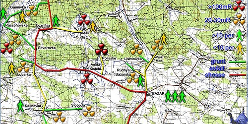
To characterize the contamination of Belarus publish maps of radioactive fallout. The maps show the level of contamination in Belarus 137Cs.
The author of cartographic materials is MNF and the Ministry of the Republic of Belarus, which together produced “Atlas modern and prognostic aspects of consequences of the Chernobyl accident in the affected areas of Belarus and Russia.”
Map pollution Gomel region 137Cs

Map pollution Gomel region by cesium-137 (1986)

Map pollution Gomel region by cesium-137 (1996)

Map pollution Gomel region by cesium-137 (2006)
In the year 20,016, 30 years after contamination will be a half-life of cesium-137 levels and surface contamination Gomel area will not exceed 15 Curie/km2 in 137Cs. (Beyond Polesskogo state radiation-ecological reserve).

Map predictive values contamination Gomel region in 2016

Map predictive values contamination Gomel region in 2056
Map pollution Minsk region 137Cs

Map pollution Minsk region in 1986
РLevels of pollution Minsk region of cesium-137 in 2046 will not exceed 1 Curie 137Cs. For details, map projections pollution Minsk region.

Predictive value of pollution Minsk region in 2046 (cesium-137)
Map pollution of Brest region by 137Cs
Brest region of Belarus contaminated in the eastern part. Maximum levels of surface contamination Brest region after the Chernobyl accident (in 1986) of about 5 – 10 Curie/km2 for 137Cs.

Карта забруднення Map pollution Brest region after the Chernobyl accident in 1986

Map pollution Brest region after the Chernobyl accident in 1996

Map pollution Brest region after the Chernobyl accident in 2006

Map prognosis contamination of cesium-137 Brest area in 2016

Map prognosis contamination of cesium-137 Brest area in 2056
Map of Mogilev region radionuclide contamination by 137Cs

Map pollution Mogilev region by cesium-137 after the Chernobyl accident (1986)

Map pollution Mogilev region by cesium-137 after the Chernobyl accident (1996)

Map pollution Mogilev region by cesium-137 after the Chernobyl accident (2006)

Estimated pollution Mogilev region of cesium-137 in 2016

Estimated pollution Mogilev region of cesium-137 in 2056
- Materials prepared according to the MNF and the Ministry of the Republic of Belarus “Atlas modern and prognostic aspects of consequences of the Chernobyl accident in the affected areas of Belarus and Russia.”