Landscapes of Chernobyl Exclusion Zone
Chernobyl Exclusion zone is situated on the Northern part of Kiev region. Shortest distance to the state boundary of Byelorussia from administrative center of Exclusion zone (Chernobyl town) is about 25 km.
Total square of the territory of Exclusion Zone is about 2600 km2.

Tectonic zoning of Chernobyl zone is situated at the East European platform, Dneprovsko – Donetsk cavity. Geomorphologic character disposal of Chernobyl Zone belong to the East European polygenic plain.
According to geo-botanical zoning the territory of Chernobyl Exclusion zone belong to European broad-leaved-forest region, Polissia sub-province, Kiev-Polissia district.
Description of water bodies, forestland and preserves Chernobyl zone
On the territory of Exclusion Zone, in particular of Chernobyl NPP site, is bounded with the river Pripyat from the North and East; grounds and forestland are joining it from the South and West.
Forestlands occupy 70 % of abandoned territory of Exclusion Zone (approximately 200 000 hectares). Forestland consists of pine-trees, oak, birch, asp and alder-tree.

Type Vegetative association on the territory of Chernobyl Exclusion Zone.
Flora of Kiev Polissia includes more than 1300 kinds of vascular plants. Some of vegetative species (11) inserted to the “Red Book of Ukraine”. There are 11 objects authorized as guarded territories (reserve, nature tombstones, etc) within the boundaries of Chernobyl Zone. Below we present of guarded nature areas that situated within the territory of Chernobyl Exclusion Zone.

Map of spread of the Natural reserves objects on the territory of Chernobyl alienation zone (red – border of Chernobyl Zone, green object – natural reserve).
1. Ilyinka’s Reserve (hydrological) Square – 2000 ha
2. Ancient Oaks Square – 12 ha
3. Professor Tovstolesov’s alder-trees collection Square – 4,8 ha
4. Ancient Settlement (Gorodische) Square – 5 ha
5. Area of ordinary pine-trees Square – 5,8 ha
6. Oaks Square – 0,02 ha
7. Petiolate oaks Square – 11 ha
8. Pine trees Square – 2,1 ha
9. Ancient oak trees Square – 14,6 ha
10. Zagorye Square – 110 ha
11. Black alder – tree over the Prypyat river (botanical) Square – 14,3 ha
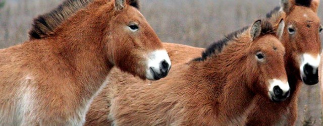
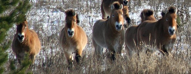
About 10 kinds of amphibians, 7 kinds of reptiles and about 240 kinds of nested birds (migrant birds and wintering ones – about 270) as well as about 60 kinds of mammals are included in a ground fauna of Kiev Polissia.
During post-accident term, in the Exclusion Zone renewal of population as regards some rare animals is observed (red lynx, ermine, otter, desman and rare species of bats), as well as rare birds (grey crane, black crane, chick-weed, etc.).
Climate condition of Chernobyl Exclusion zone
Chernobyl zone climatic conditions are rather good studied. Around chernobyl’s territories are 3 meteorological stations (Chernobyl, Polisske, Bragin) in radius of 50 km. On the distance 70 – 110 km situated meteorological stations Teterev, Ovruch, Oster, Chernigov. It takes a rather long period to make observation per all the stations. To make description of the region climatic conditions, the data of the nearest meteorological station placed in Chernobyl town.

According to the data of monitoring data of Chernobyl’s meteorological station, average annual temperature of air is 7.2 0С, average temperature of the most cold month (January) is minus 6.1 0С.
It is raining and hailing during a warm period of time (since Aptil till October), but rains accompanied with snow, wet snow and snow itself are occurred in cold season of a year. Minimal value of precipitations is fallen down since December till March. Average level of annual precipitations layer among the many years’ cycle is 600 mm.
Soil character of Chernobyl zone

Lithologic structure of the most widely distributed type soil on Exclusion zone:
Top layer of soil, named us “Soil-vegetable layer” have a thickness 0.2 – 5 m and presented by loam sand and loams, containing a majority of the plants roots. On the picture you can see the view of Chernobyl’s soddy-podzolic soils (0-100 sm layer).
Next layer – “Soils of flood-plain phase” presented by the powder sands, fine and middle size sand, loamy sand and rarely by loamy soil.
Soils are characterized by the heterogeneous settling. Thickness of flood-plain sediments varies within the limits of 5 to 7 m.
Reference:
Website of Chernobyl NPP – http://www.chnpp.gov.ua/articles.php?lng=ru&pg=5356
Архипов А.Н., Озорнов А.Г., Паскевич С.А. Биологическая доступность Cs-137 и Sr-90 в почвах 30-км зоны ЧАЭС. В сб.: “Чернобыль-94″ Доклады IV международной научно-технической конференции “Итоги 8 лет работ по ликвидации последствий аварии на ЧАЭС. – Чернобыль 1996 т.1, с.337-349